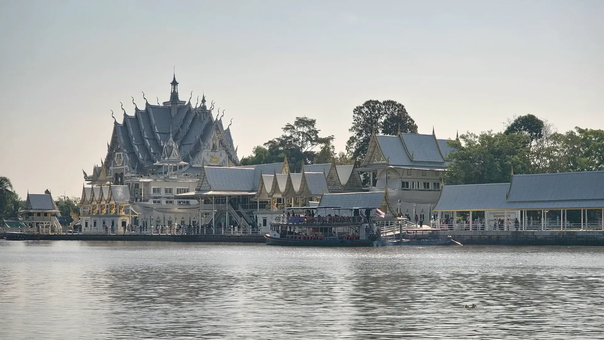
Chachoengsao is an eastern province about 75 km from Bangkok along the Bang Pakong River, known for Wat Sothon, farming, river markets and a forested east. Sourced from the NSO, DNP and the provincial office.
EastRegion
Mueang ChachoengsaoProvincial capital
ฉะเชิงเทราThai name
Registered population
Chachoengsao had 733,850 people in the civil registration system in August 2026 (730,260 Thai nationals and 3,590 registered non-Thai nationals), according to the Department of Provincial Administration. That is the 34th largest registered population of Thailand's 77 provinces and about 1.1 percent of the national registered total of 65,677,170.
This is the number of people entered in the house registration system for the province, not a count of everyone who lives there. People who work in another province often stay registered at home, and most foreigners on short stays are not in the registry at all. Official table for August 2026 (read by BAANLYY on 14 November 2026) · Compare all 77 provinces
About Chachoengsao
Chachoengsao, which locals call Paet Riu, sits on the Bang Pakong River about 75 kilometres from Bangkok by Highway 304, according to the National Statistical Office (NSO) provincial report for 2025. It covers about 5,352 square kilometres and holds 733,131 people across 11 districts. The west is flat river plain and farmland. The east, toward Sa Kaeo, rises into forest and hills and includes part of the Khao Ang Rue Nai Wildlife Sanctuary.
A visitor finds a river town with a famous Buddha image at Wat Sothon, a 100-year-old riverside market, a city fort from the reign of Rama III and temples that draw pilgrims from Bangkok. A person weighing a move finds a province with a large provincial economy, a mix of farms and factories, a good road and rail link to the capital and a quiet rural east. The NSO puts gross provincial product at 450,808 million baht for 2023.
Understand two things first. Chachoengsao is a working province, not a resort, and the official sources we could open say little about foreign residents, rents or house prices. BAANLYY does not yet have local listings, partnered landlords or property managers in Chachoengsao, so use this page as a reference guide and check everything on the ground.
Chachoengsao at a glance
Area
About 5,352 square kilometres (3,344,375 rai), as given in the NSO provincial statistical report 2025 source
Population in 2024
733,131 people, up 0.35 percent on 2023, with a density of 136.98 people per square kilometre (NSO report; the largest district, Mueang Chachoengsao, has 164,412) source
Administrative divisions
11 districts, 93 sub-districts and 892 villages in 2024 source
Distance from Bangkok
About 75 km by Highway 304; about 90 km by Highway 34 and 314; about 106 km by Highway 3 and 314; about 61 km along the Eastern railway line source
Gross provincial product
450,808 million baht in 2023, or 490,005 baht per person per year, as reported by NSO from the national planning agency source
Temperature extremes in 2024
Highest 41.2 C and lowest 15.8 C at the Chachoengsao weather station source
Forest cover
About 499,960 rai, or 14.95 percent of the province, in 2023 source
Hospitals and beds in 2024
15 hospitals (11 government, 4 private) with 1,655 beds, 337 doctors, 83 dentists, 138 pharmacists and 1,769 nurses source
Khao Ang Rue Nai Wildlife Sanctuary
674,352 rai across Chachoengsao, Sa Kaeo, Chanthaburi, Rayong and Chon Buri; first declared in 1977 (DNP) source
Where Chachoengsao sits
Chachoengsao lies in eastern Thailand. The NSO report says it borders Prachin Buri and Nakhon Nayok to the north, Chon Buri, Chanthaburi and the Gulf of Thailand to the south, Prachin Buri and Sa Kaeo to the east, and Samut Prakan, Pathum Thani and Bangkok to the west.
The report splits the land in two. The flat western part, about 1,250,000 rai, covers Bang Nam Priao, Bang Khla, Ratchasan, Khlong Khuean, Mueang Chachoengsao, Ban Pho and Bang Pakong districts, and the Bang Pakong River runs through it to the sea at Bang Pakong. The provincial office's general page also gives the plain as 1,250,000 rai, and puts it at 37.4 percent of the province. The coastline is only about 12 kilometres long.
The eastern part, about 1,786,976 rai or nearly half the province, is upland, forest and hills in Sanam Chai Khet and Tha Takiap districts and parts of Phanom Sarakham and Plaeng Yao. The soil there suits field crops. The report names the Khwae Ra Bom and Si Yat forests, the Somdet Phra Pinklao arboretum at Khao Hin Son and the Khao Ang Rue Nai Wildlife Sanctuary. Forest cover was about 499,960 rai, or 14.95 percent of the province, in 2023.
Climate and the seasons
The NSO report gives only two climate numbers for Chachoengsao: in 2024 the provincial weather station recorded a high of 41.2 degrees Celsius and a low of 15.8. Those are single-year extremes, not averages, so they show the range rather than a typical day.
The Department of National Parks says the monsoon trough crosses the five-province forest around Khao Ang Rue Nai and that rainfall is heavier in the south of that area than in the north. We did not find official monthly rainfall, rainy-day counts or long-term normals for Chachoengsao itself, so we give none. The province has a low coast and river plain, and we did not find an official flood-risk map. If you plan a stay, visit in the wet months as well as the dry ones.
History and culture
The nickname Paet Riu, meaning eight strips, comes from a local story the NSO report repeats: the river teemed with snakehead fish so large that one had to be sliced into eight strips to dry. The report says the official name Chachoengsao may come from a Khmer word for the Bang Pakong River, "deep canal", which wore down over time. These are explanations passed down, not documented origins.
The report says a town is presumed to have existed here in the Ayutthaya period, as an inner town in the reign of King Borommatrailokkanat (1448 to 1488 by the Western calendar). It describes clearer evidence under King Naresuan, who used the town to gather troops because the ground suited guerrilla war. In the reign of Rama V it became a town in Monthon Prachin Buri, and in 1933 (BE 2476) it became a province.
The city fort on Marupong Road was built in the reign of Rama III, according to the report, and in the reign of Rama V it served as a base for crushing the Ang Yi uprising, which the report describes as a revolt by Chinese opium traders. The report says Wat Pitulathirat Rangsarit, the "town temple", was built in 1834 (BE 2377) when the city wall was raised, and that Rama V gave it its present name in 1908 (BE 2451). It also records that the Taksin monument at Pak Nam Cho Lo marks a fight with Burmese forces after Taksin broke out of Ayutthaya.
How people earn a living here
The NSO report, quoting the national planning agency, puts Chachoengsao's gross provincial product at 450,808 million baht in 2023, or 490,005 baht per person per year. That is a large provincial economy next to Bangkok, but we did not open the report's national-accounts tables, so we cannot say how that output splits between industry, trade and farming.
The report says most people work in farming: rice, field crops and fruit orchards, plus livestock. The key crops it lists are rice, cassava, feed corn and sugarcane; orchard and tree crops include mango, areca nut, coconut and rubber. Chickens, ducks and pigs are the main livestock, and many families run fish and shrimp ponds.
At Ban Pak Nam in Mueang Chachoengsao the report describes the only fresh palm-sugar drink producer in the east, where visitors can watch sugar made from toddy palm sap. The report also notes the Bang Pakong river barrage at Ban Phai Sawek in Mueang Chachoengsao. We did not open the industrial statistics, so we give no factory counts or investment figures.
Getting to Chachoengsao
The NSO report gives three road routes from Bangkok. Through Min Buri on Highway 304 it is about 75 kilometres. Along Bang Na-Trat (Highway 34), then Highway 314, it is about 90. Through Samut Prakan and Bang Pakong on Highway 3, then Highway 314, it is about 106. The railway distance is given as about 61 kilometres on the Eastern line.
On public transport, the report says buses leave the Northern Bus Terminal (Mo Chit) every 30 minutes, including air-conditioned buses on the motorway, and that the Eastern Bus Terminal (Ekkamai) runs ordinary and air-conditioned buses. It says trains run daily from Bangkok (Hua Lamphong), the first at 05:55 and the last at 18:50. These details come from a printed report and timetables change, so confirm with the operators before you travel.
The report also mentions passenger boats between the town and nearby communities. We found no official source this run for the nearest commercial airport or flight times, so we list none. Inside the province, the east (Sanam Chai Khet, Tha Takiap) is far from the main road, about 90 kilometres from town for the Khlong Si Yat reservoir, so a car helps.
Places worth knowing in Chachoengsao
Wat Sothon Wararam Worawihan (วัดโสธรวรารามวรวิหาร)
Temple and pilgrimage site
On the Bang Pakong River in Chachoengsao city. The NSO report says it was once called Wat Hong and shelters Luang Pho Buddha Sothon, a stucco seated Buddha thought to have been enshrined here around 1770. Tradition says the image floated upstream. Locals revere it as the town's guardian.
On the Bang Pakong River in Bang Kaeo sub-district. The NSO report says it holds the largest reclining Ganesha image in Thailand, 16 metres high and 22 metres long. The report presents it as a sacred figure for local believers, which is a statement of faith.
An old market on Supakit Road in Na Mueang sub-district, over 100 years old according to the NSO report, kept to preserve river-community life. It sells curry rice, noodles, old-style coffee, Thai and Chinese sweets and souvenirs, and the report says it opens on Saturdays, Sundays and public holidays.
On Marupong Road in Na Mueang sub-district, built in the reign of Rama III according to the NSO report. In the reign of Rama V it was a base for putting down the Ang Yi revolt. The front is now a public park with a view of the river and cannon along the wall.
Wat Pitulathirat Rangsarit (Wat Mueang) (วัดปิตุลาธิราชรังสฤษฎิ์ (วัดเมือง))
Historic temple
The town temple, built in 1834 when the city wall was raised. The NSO report says Rama V renamed it in 1908 and that its prang closely resembles the Eight Prang in Bangkok's Temple of the Emerald Buddha, so it is believed to be the work of craftsmen from the capital.
Khao Hin Son Development Study Centre (ศูนย์ศึกษาการพัฒนาเขาหินซ้อน)
Royal agricultural study centre
In Phanom Sarakham district beside Highway 304 at km 51 to 52, a royal-initiative project on 1,929 rai. The NSO report says it won a tourism industry award for agricultural tourism in 2004 and offers accommodation for young people and anyone who wants to learn about farming.
Khao Ang Rue Nai Wildlife Sanctuary (เขตรักษาพันธุ์สัตว์ป่าเขาอ่างฤาไน)
Wildlife sanctuary
The Department of National Parks gives 674,352 rai across Chachoengsao, Sa Kaeo, Chanthaburi, Rayong and Chon Buri, first declared in 1977 and enlarged in 1992. It lists 125 mammal and 352 bird species. The NSO report says you need permission before entering.
In Bang Khla district, about 23 kilometres from Chachoengsao town according to the NSO report. Large flying foxes roost in the trees in the daytime and fly out to feed at dusk. Boats on the Bang Pakong River pass the temple.
The basics are documented. In academic year 2024 the province had 357 schools (310 under the basic education commission, 27 private, 13 under local government and 7 under other bodies), with 4,742 classrooms, 5,915 teachers and 107,378 pupils. For health care in 2024 the NSO report counts 15 hospitals, 11 government and 4 private, with 1,655 beds, 337 doctors, 83 dentists, 138 pharmacists and 1,769 nurses.
Utilities are counted too. For the 2024 fiscal year the report gives 296,323 electricity users, and in 2024 six water-supply offices served 153,078 water users. Local government is made up of one provincial administrative organisation, one city municipality, 33 sub-district municipalities and 74 sub-district administrative organisations.
What we cannot tell you is the cost of living, typical rents, internet speed or how many foreign residents live here, because we found no official source for any of them. The province is close enough to Bangkok that many daily needs are well covered on paper, but we did not open commuting data. If you are thinking of moving, visit in more than one season, travel the roads you would use daily and talk to residents.
Renting, buying and visas
BAANLYY does not yet have local listings, partnered landlords or property managers in Chachoengsao, so this page is a reference guide and not a property search. Thai law limits what foreigners can own, and the rules for condominiums, leaseholds and company structures differ from one another, so read BAANLYY's ownership guides and take advice from a qualified Thai lawyer before you commit money.
Your visa route matters more than the province you choose. BAANLYY's visa guides cover the long-stay options in plain language. Nothing on this page is legal, tax or immigration advice, and BAANLYY is a property portal and is not a party to independent owners', agents' or agencies' leases or sales.
What we could not confirm
We left these out rather than guess. If you hold a current official source for any of them, tell us at hello@baanlyy.com.
Cost of living, typical rents and house prices. We found no official source.
The number and make-up of foreign residents in Chachoengsao.
Monthly rainfall, rainy days and long-term climate normals from the Thai Meteorological Department. The NSO report gives only the 2024 temperature extremes.
Flood-risk figures for individual districts.
The nearest commercial airport and flight times, and current bus and train timetables. The NSO report's schedule details come from a printed report and may be out of date.
Industrial statistics, factory counts and the split of the provincial economy by sector. We did not open those tables of the NSO report.
The provincial office pages did not load in full, so we cite them only for the plain-area figure visible in the search excerpt (1,250,000 rai, 37.4 percent).
Map coordinates for the capital and the places listed. We found no source that names each place with its district, so no map is drawn.
FAQ
Questions about Chachoengsao
How far is Chachoengsao from Bangkok?
The NSO report gives about 75 kilometres by Highway 304, about 90 by Highway 34 and 314, and about 106 by Highway 3 and 314. The railway distance is given as about 61 kilometres.
How big is Chachoengsao province?
The NSO provincial report gives about 5,352 square kilometres, which is 3,344,375 rai, with 11 districts, 93 sub-districts and 892 villages in 2024.
How many people live in Chachoengsao?
The NSO report lists 733,131 people in 2024, up 0.35 percent on 2023. The registered population section on this page gives the official registry figure for a later month.
Why is Chachoengsao called Paet Riu?
The NSO report repeats a local story that snakehead fish here were so large each had to be cut into eight strips to dry. It is a tradition, not a documented origin.
What is Wat Sothon known for?
It houses Luang Pho Buddha Sothon, a seated Buddha image locals revere as the town's guardian. The NSO report says it was probably enshrined here around 1770.
What does Chachoengsao's economy depend on?
The NSO report puts gross provincial product at 450,808 million baht in 2023, and says most people farm rice, cassava, feed corn, sugarcane, fruit, livestock and fish or shrimp.
Does BAANLYY have rental listings in Chachoengsao?
Not yet. BAANLYY has no confirmed local listings, landlords or property managers in Chachoengsao, so check rents, contracts and neighbourhoods on the ground before committing.
Facts on this page were checked against the sources above on 2026-10-12. Official figures change; confirm current numbers and rules with the relevant authority before relying on them.
BAANLYY LLC is a Nevada property portal. Homes are listed by independent owners, agents and agencies; BAANLYY is not a party to their leases or sales. Owners who contact BAANLYY directly can have their home listed and managed by the BAANLYY founding team under a written agreement. General information, not legal, tax, immigration or financial advice.