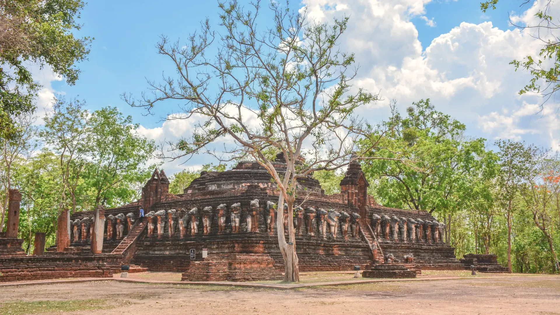
Kamphaeng Phet is a lower-northern farming province on the Ping River, home to a UNESCO World Heritage historical park, three national parks and Thailand's northern banana country. Facts come from Thai government and UNESCO sources.
NorthRegion
Mueang Kamphaeng PhetProvincial capital
กำแพงเพชรThai name
Registered population
Kamphaeng Phet had 693,688 people in the civil registration system in August 2026 (692,124 Thai nationals and 1,564 registered non-Thai nationals), according to the Department of Provincial Administration. That is the 38th largest registered population of Thailand's 77 provinces and about 1.1 percent of the national registered total of 65,677,170.
This is the number of people entered in the house registration system for the province, not a count of everyone who lives there. People who work in another province often stay registered at home, and most foreigners on short stays are not in the registry at all. Official table for August 2026 (read by BAANLYY on 14 November 2026) · Compare all 77 provinces
About Kamphaeng Phet
Kamphaeng Phet sits on the Ping River in lower northern Thailand, 358 kilometres from Bangkok along Highway 1, Phahonyothin Road. Its main draw is the Kamphaeng Phet Historical Park, laterite ruins that form part of a UNESCO World Heritage property alongside Sukhothai and Si Satchanalai. West of the river the land climbs into forested hills and three national parks. East of it is flat farmland.
At the end of December 2025 the Department of Provincial Administration counted 696,972 registered residents, and the National Statistical Office's table shows the number falling every year since 2021, when it was 712,143. The provincial capital, Mueang Kamphaeng Phet, has 205,797 of them. Most people farm rice, sugar cane, cassava, maize and bananas, and there is no railway line or airport in the province.
If you are weighing a move or a long stay, read this page as a map of what is documented. We could confirm area, registered population, the 2023 economy, the 2025 health and school counts, 2025 rainfall and the main places to visit. We could not confirm rents, the size of the foreign community, official climate normals or any bus timetable, and the list at the end of this page says so. BAANLYY does not have local listings in Kamphaeng Phet.
Kamphaeng Phet at a glance
Region and neighbours
Lower northern Thailand. Tak and Sukhothai lie to the north, Phitsanulok and Phichit to the east, Nakhon Sawan to the south and Tak (Umphang district) to the west. source
Area
8,607.5 square kilometres, or about 5,379,687 rai, of which about 5,358 square kilometres is farmland and about 2,185 square kilometres is forest (Ministry of Commerce provincial page). The same page's district table adds up to 8,252.63 square kilometres, and the density figure in the National Statistical Office report implies a third number, so treat area as approximate. source
Registered population
696,972 people at the end of December 2025 (342,943 men and 354,029 women), from Department of Provincial Administration data. 189,152 lived inside municipal areas and 507,820 outside them. The registry includes non-Thai nationals who are on a house registration. source
Population trend
Registered population fell from 712,143 in 2021 to 696,972 in 2025, a decline of between 0.47 and 0.58 percent a year. Density in the 2026 report is 79.45 people per square kilometre. source
Administrative divisions
11 districts, 78 subdistricts and 963 villages in 2025. Local government has 3 town municipalities, 22 subdistrict municipalities and 64 subdistrict administrative organisations. source
Distance from Bangkok
358 kilometres by Highway 1, Phahonyothin Road source
Gross provincial product
121,156 million baht in 2023, or 155,404 baht per person (NESDC figures quoted by the National Statistical Office) source
Rainfall, 2025
1,713.6 millimetres for the year; May was the wettest month at an average of 358.2 millimetres. The report classes the climate as tropical savanna (Koppen Aw). source
Health facilities, 2025
12 public hospitals, 2 private hospitals, 125 subdistrict health-promoting hospitals, 7 public health service centres and 382 clinics source
World Heritage
Kamphaeng Phet is one of three towns in UNESCO's Historic Town of Sukhothai and Associated Historic Towns; the Kamphaeng Phet part covers 338 hectares. The National Statistical Office and the Ministry of Commerce both give the listing date as 12 December 1991. source
Where Kamphaeng Phet sits
The Ping River crosses the province from north to south over about 104 kilometres, entering at Ban Wang Chao. The 2026 statistical report describes three kinds of land. The lower Ping floodplain, a river-terrace plain at roughly 43 to 107 metres above sea level, covers the east and south. Low hills mixed with plain lie in the north and centre, and complicated mountains fill the west, where the streams that feed the Ping begin.
Land use follows the geography. The report says about 31.43 percent of the province is rice paddy, mostly on the flat eastern side in districts such as Mueang, Lan Krabue, Sai Ngam, Khlong Khlung and Khanu Woralaksaburi. Field crops cover about 28.01 percent, spread across the west bank in Khlong Lan, Pang Sila Thong, Kosamphi Nakhon and parts of Mueang. The Ministry of Commerce counts 2,184.7 square kilometres of forest.
The soil is sandy loam, and the report calls it very fertile. It says that fertility has pushed farmers into forest edges, which is the pressure behind the encroachment it mentions. For water, the Royal Irrigation Department runs medium and small schemes, and a national electric pumping programme has put nine pumping stations on the Ping to supply farms.
Climate and the seasons
The 2026 statistical report classes the climate as tropical savanna and describes three seasons. The rainy season runs from May to October under the southwest monsoon. The cool and dry season runs from November to February under the northeast monsoon, which brings cold, dry air from China. The hot season runs from late February to April, when the report says the weather is hot and very dry.
The measured figure we opened is for 2025. Average rainfall for the year was 1,713.6 millimetres, and May was the wettest month with an average of 358.2 millimetres. That is one year, not a climate normal. We did not find the Thai Meteorological Department's 30-year averages or temperature records for Kamphaeng Phet, and they are listed as unconfirmed below.
For anyone thinking of living here, the practical point is that the Ping plain is low and flat in the east and south, and the monsoon rains arrive early, in May. Ask neighbours and local officials which villages flood, and in which months, before you take a house. The hot season is the harder time of year to visit, so try to see the place in March or April as well as in the cool season.
History and culture
The provincial account says Kamphaeng Phet has been an important town since the Dvaravati period, and that it stood in a cluster of old towns: Chakangrao, Nakhon Chum, Trai Trueng, Thep Nakhon and Khon Thi. It was a frontier town of Sukhothai, ranked as a royal-child city, with moats, walls and forts. The chronicle account says Chakangrao, on the east bank of the Ping, was built by King Loe Thai, the fourth Sukhothai king, around 1890 in the Buddhist Era (about 1347 CE). It says Nakhon Chum on the west bank was built later, under King Li Thai. Treat those dates as the chronicle's, not as an archaeologist's.
UNESCO's description fits the picture. It says Kamphaeng Phet stood at the southern frontier of the Sukhothai kingdom, had important military functions in protecting it from foreign intruders, and provided security for its trading network. All three towns shared infrastructure for controlling water and were linked by a highway called Thanon Phra Ruang. Under Thai heritage law the Fine Arts Department looks after the historical park.
The statistical report says Kamphaeng Phet was also the second town governed by King Taksin the Great, who held the title Phraya Vachiraprakan, and that the town was made a province in 1916 (Buddhist Era 2459). The report repeats Prince Damrong's judgement that the old city wall is one of the best preserved and most beautiful in Thailand. Local festivals listed include the Nop Phra and Len Phleng tradition, the Sart Thai banana festival, a noodle festival, a long-boat race on the Ping and a giant freshwater prawn festival.
How people earn a living here
Farming and fishing employ most people, according to the report. The main crops are rice, sugar cane, cassava and maize, and the province also does wholesale and retail trade, manufacturing, hotels and food service, and construction. The 2023 gross provincial product was 121,156 million baht, which works out at 155,404 baht per person.
The standout crop is the Kluai Khai, the small sweet banana that features in the provincial slogan. The report says Kamphaeng Phet is the largest producer of Kluai Khai in the north. The slogan also mentions laterite, amulet crypts, the Lan Krabue oil and the World Heritage listing. The report names crude oil and natural gas among the resources of national economic value, but it gives no production figure, so we do not.
Utilities give a sense of scale. In the 2025 fiscal year the Provincial Electricity Authority sold 2,170.91 million kilowatt-hours to 243,584 customers. In 2025 the waterworks sold 748,500 cubic metres of water to 39,630 users. The province has 11 post offices.
Getting to Kamphaeng Phet
The statistical report says road is the only convenient way to reach Kamphaeng Phet: there is no railway and no airport in the province. Bangkok is 358 kilometres away along Highway 1, Phahonyothin Road. The report says the northern railway line passes through neighbouring Phichit and Phitsanulok provinces, and the nearest airports are at Sukhothai and Phitsanulok.
The report adds that the road is faster and easier than going via those stations. It gives no timetables, fares or journey times, and we did not find an official bus schedule, so those are listed below as unconfirmed. We did not confirm bus services.
Inside the province, the Historical Park, the riverside and the provincial hall are all in or near the Mueang district. The three national parks are in the west of the province, away from the town.
Places worth knowing in Kamphaeng Phet
Kamphaeng Phet Historical Park (อุทยานประวัติศาสตร์กำแพงเพชร)
UNESCO World Heritage site
A large old town the report says is at least 700 years old, listed by UNESCO on 12 December 1991 as part of the Sukhothai serial property. The east side is the town of Kamphaeng Phet itself, built big in laterite. The smaller west side is Nakhon Chum, built in brick. Their art mixes Sukhothai and Ayutthaya styles. UNESCO gives the Kamphaeng Phet part as 338 hectares.
A quiet temple in Mueang Kamphaeng Phet with an ordination hall in the centre and a viharn housing Luang Pho Phet, a bronze Buddha in the Chiang Saen style, in the subduing-Mara posture. The report says it is more than 800 years old and describes it as the largest and most complete bronze of its kind in Thailand. The report calls it a guardian image of the province.
The report calls it an old, important temple of at least 400 years. Its highlight is a Rattanakosin-style scripture hall (Ho Trai) raised on stilts in a pond, a local design meant to keep insects, termites and rats from damaging the Tripitaka. The Buddha image inside the ordination hall was presented by King Bhumibol and named Phra Phuttha Wachiraprakan.
A forest park that straddles Pang Sila Thong district in Kamphaeng Phet and Mae Wong and Mae Poen districts in Nakhon Sawan. The report lists wildlife watching, camping, waterfalls and trekking, with the Chong Yen viewpoint, Kio Krathing viewpoint, Mae Krasa waterfall and Mo Ko Ju, the park's highest peak. It recommends visiting in the cool season.
Khlong Wang Chao National Park (อุทยานแห่งชาติคลองวังเจ้า)
National park (shared with Tak)
Covers parts of Kosamphi Nakhon, Khlong Lan and Mueang districts in Kamphaeng Phet and Wang Chao district in Tak, within the Ping River basin. The report names Tao Dam, Khlong Wang Chao, Khlong Samor Kluai and Khao Yen waterfalls, the Nakhi Ri rapids, a hot spring used by wildlife, Tham Thep Phanom cave and a Karen village.
In Khlong Lan district. The report calls Khlong Lan waterfall large, falling from a cliff of more than 100 metres, and says there is water to swim in all year. It also lists Kaeng Ko Roi, Khlong Suan Mak and Khlong Nam Lai waterfall, with a camping area. Weekends will be busier than weekdays.
Bun Bridge at Wat Thung Sanun Rattanaram (สะพานนาบุญ วัดทุ่งสนุ่นรัตนาราม)
Farm-tourism site and temple
A 356-metre walkway across rice fields, which the report calls the longest of its kind in the lower north. Its four arms lead to a shrine to Mae Phosop, the rice goddess, at the centre. The temple also serves as a summer meditation site for monks and novices and hosts merit-making events. Camping is allowed in the field.
The documented basics are decent for a province of about 700,000 people. In 2025 the report counts 12 public hospitals, 2 private hospitals, 125 subdistrict health-promoting hospitals, 7 public health service centres and 382 clinics. We did not open a doctor or bed count for this province, so we cannot say how thin the cover is. Ask which hospital handles your specialty before you rely on the totals.
For schooling, the 2025 school year had 700 schools, 6,275 classrooms, 6,051 teachers and 96,862 pupils from kindergarten to upper secondary. Most residents are Buddhist, and temples and monasteries are spread across the province. We found nothing official on international schools.
What we could not find is just as important. There is no official figure here for cost of living, typical rents, internet speed or the number of foreign residents. With no railway and no airport, a car matters. Expect Thai-language services outside the town, and visit in both the hot season and the rains before deciding. The registered population is shrinking slowly, so do not assume a growing housing market.
Renting, buying and visas
BAANLYY does not run a rental hub or local listings for Kamphaeng Phet, so this page is a reference guide and not a property search. Thai law limits what foreigners can own, and the rules for condominiums, leaseholds and company structures differ from one another, so read BAANLYY's ownership guides and take advice from a qualified Thai lawyer before you commit money.
Your visa route matters more than the province you choose. BAANLYY's visa guides cover the long-stay options in plain language and point to the official Thai sources for each. Nothing on this page is legal, tax or immigration advice, and BAANLYY is a property portal and is not a party to independent owners', agents' or agencies' leases or sales.
What we could not confirm
We left these out rather than guess. If you hold a current official source for any of them, tell us at hello@baanlyy.com.
A single agreed area. The Ministry of Commerce gives 8,607.5 square kilometres but its own district table sums to 8,252.63, and the statistical report's density figure implies another value.
The count of residents outside municipal areas. The report text says 507,208 but its own table gives 507,820, which adds up to the 696,972 total. This page uses the table.
Cost of living, typical rents and house prices. We found no official source.
The size and make-up of the foreign community in Kamphaeng Phet.
Temperature records and official 30-year climate normals from the Thai Meteorological Department. The only measured figures here are rainfall for 2025.
Doctor, dentist and hospital bed counts for 2025. We opened the facility counts only.
Bus and minibus timetables and journey times to Kamphaeng Phet. The report says only that road is the convenient way in.
The exact founding dates of Chakangrao and Nakhon Chum. The sources give a chronicle date of about 1890 in the Buddhist Era and do not give an archaeological date.
How much of the historical park is original and how much was restored by the Fine Arts Department.
Map coordinates for the provincial capital and the places listed. We did not find a government source that names each place and district, so no map is drawn on this page.
FAQ
Questions about Kamphaeng Phet
Is Kamphaeng Phet a UNESCO World Heritage site?
Yes. Kamphaeng Phet is one of three towns in UNESCO's Historic Town of Sukhothai and Associated Historic Towns. The National Statistical Office and the Ministry of Commerce give the listing date as 12 December 1991.
Can you get to Kamphaeng Phet by train or plane?
Not directly. The statistical report says the province has no railway and no airport. The northern line runs through Phichit and Phitsanulok, and the nearest airports are at Sukhothai and Phitsanulok, so most people drive Highway 1 from Bangkok.
How many people live in Kamphaeng Phet?
The Department of Provincial Administration counted 696,972 registered residents at the end of December 2025. The registered population has fallen each year since 2021, when it was 712,143.
What is Kamphaeng Phet known for besides its ruins?
Bananas and farming. The report says it is the largest producer of Kluai Khai, the small sweet banana, in the north, and the main crops are rice, sugar cane, cassava and maize.
When does it rain in Kamphaeng Phet?
The rainy season runs from May to October. In 2025 the province averaged 1,713.6 millimetres of rain for the year, and May was the wettest month at 358.2 millimetres on average.
Does BAANLYY have rentals or property listings in Kamphaeng Phet?
No. BAANLYY does not yet have local listings, partnered landlords or property managers in Kamphaeng Phet. This page is a reference guide built from Thai government sources and should not be read as evidence of a rental market.
Where does the information on this page come from?
The National Statistical Office's 2026 Kamphaeng Phet provincial statistical report, the Ministry of Commerce provincial page and UNESCO's World Heritage page. Anything we could not confirm from those is listed at the end of the page as not confirmed.
Facts on this page were checked against the sources above on 2026-10-12. Official figures change; confirm current numbers and rules with the relevant authority before relying on them.
BAANLYY LLC is a Nevada property portal. Homes are listed by independent owners, agents and agencies; BAANLYY is not a party to their leases or sales. Owners who contact BAANLYY directly can have their home listed and managed by the BAANLYY founding team under a written agreement. General information, not legal, tax, immigration or financial advice.