Thailand · Central · Samut Songkhram
Samut Songkhram (สมุทรสงคราม)
Samut Songkhram is Thailand's smallest province: 416.7 sq km of canals, coconut and fruit orchards at the Mae Klong river mouth, about 65 km from Bangkok. Figures from NSO and TAT.
Samut Songkhram is Thailand's smallest province: 416.7 sq km of canals, coconut and fruit orchards at the Mae Klong river mouth, about 65 km from Bangkok. Figures from NSO and TAT.
Samut Songkhram had 184,295 people in the civil registration system in August 2026 (183,016 Thai nationals and 1,279 registered non-Thai nationals), according to the Department of Provincial Administration. That is the 77th largest registered population of Thailand's 77 provinces and about 0.3 percent of the national registered total of 65,677,170.
This is the number of people entered in the house registration system for the province, not a count of everyone who lives there. People who work in another province often stay registered at home, and most foreigners on short stays are not in the registry at all. Official table for August 2026 (read by BAANLYY on 14 November 2026) · Compare all 77 provinces
Samut Songkhram is the smallest province in Thailand. The National Statistical Office (NSO) puts it at 416.7 square kilometres, about 0.08 percent of the country, on the Gulf of Thailand at the mouth of the Mae Klong River. It is roughly 65 kilometres southwest of Bangkok along Highway 35. The province is flat and criss-crossed by canals, and NSO says it is known as the last Venice of Siam.
People here live from coconut and fruit orchards, fishing and small food factories. NSO's 2024 count is 186,784 registered residents in 3 districts, 36 sub-districts and 284 villages, and 81.2 percent of them live outside municipal areas. Visitors come for the Amphawa floating market, the Maeklong railway market where trains pass through the stalls, and the Don Hoi Lot mudflat. Expect a small, quiet, mostly rural province, not a city.
If you are weighing a move, treat this page as a fact sheet rather than a sales pitch. Official sources give good numbers on people, hospitals, schools and the economy, and we quote them. They do not give rents, house prices, internet speeds or the foreign community, so we say so. BAANLYY does not yet have local listings, partnered landlords or property managers in Samut Songkhram, so any checking would be yours to do on the ground.
| Area | 416.7 square km (260,442 rai), the smallest province in Thailand and about 0.08 percent of the country, according to the NSO Provincial Statistical Report 2025. We did not find a second official figure to compare it with. source |
|---|---|
| Registered population | 186,784 people in 2024 (89,040 men and 97,744 women), from Department of Provincial Administration records quoted by NSO. The previous edition of the report gave 187,993 for 2023. source |
| Districts, sub-districts and villages | 3 districts (Mueang Samut Songkhram, Bang Khonthi and Amphawa), 36 sub-districts and 284 villages in 2024. source |
| Distance from Bangkok | About 65 km southwest of Bangkok along Highway 35 (Thon Buri to Pak Tho), per NSO. source |
| Gross provincial product, 2023 | 29,320 million baht, or 167,164 baht per person. NSO, citing the national planning agency, ranks that 3rd in the western region and 22nd in the country. source |
| Population density | 448.25 people per square km in 2024, with 77,393 houses in the province. Only 35,031 people (18.8 percent) live inside municipal areas. source |
| Hospitals and clinics, fiscal 2024 | 4 hospitals (3 government and 1 private), 49 sub-district health-promoting hospitals, 58 clinics of all types, 82 doctors, 27 dentists, 33 pharmacists, 456 nurses and 405 beds. That is one doctor per 2,278 people. source |
| Coastline and river | About 23 km of coast. The Mae Klong River is 520 km long and runs 22 km through the province, past every district. source |
Samut Songkhram sits in the lower central region on the Gulf of Thailand where the Mae Klong River reaches the sea. NSO lists its borders as Ratchaburi and Samut Sakhon to the north, Samut Sakhon to the east, the Gulf of Thailand and Phetchaburi to the south, and Ratchaburi and Phetchaburi to the west.
Almost the whole province is low coastal plain with soil of clay mixed with sand, sloping gently toward the sea. NSO counts 335 canals and 1,947 smaller ditches branching off the Mae Klong, which is why the report calls it the last Venice of Siam. The coast is about 23 kilometres long. Daily tides push seawater up the river and canals, so the province splits into three zones by water quality.
NSO describes the salt-water zone as the strip from the shore inland by about 3 kilometres, in Mueang district. Next comes a brackish zone of about another 3 kilometres, in Amphawa and Mueang. Beyond that is fresh water, usable for drinking and household use, covering northern Amphawa and all of Bang Khonthi. If you are looking at land, ask which zone it is in.
NSO says the province is mostly shaped by the southwest monsoon from the Gulf of Thailand and the South China Sea, which brings a fair amount of rain in the wet season. Being near the sea keeps the air humid all year, and the report says winters are not very cold and summers not very hot. It gives an average temperature of about 29.3 degrees Celsius over the year.
The report divides the year into three seasons that differ from the national season dates used by the Thai Meteorological Department. It gives the hot season as March to mid-June, the rainy season as mid-July to October, and the cool season as November to mid-February. It gives average rainfall of 1,030.8, but prints the unit as milligrams, which is clearly a misprint. We read it as millimetres and flag it below. We did not open official long-term climate normals, so treat these as the province's own summary.
NSO says the province was once called Mueang Mae Klong. The report presumes the first settlers were river people from Uthai Thani who moved here when their old river silted up, and who named their village Ban Mae Klong after their old home. It also gives two stories about the name's link to a large drum at Wat Yai. In one, a district officer transferred from Kanchanaburi in the reign of King Chulalongkorn had a huge drum made from a Kanchanaburi log and gave it to the temple. In the other, a drum floated down the river and locals kept it. The provincial seal shows a drum floating on water between two coconut palms.
King Rama II, Phutthaloetla Naphalai, is the province's best known royal link. NSO says Amphawa is his birthplace, with a memorial park and a temple, Wat Amphawan Chetiyaram, holding his ashes in a prang. The ordination hall has murals of his life and of plays he wrote, and doors and windows that record Thai topiary art. NSO also records Bang Kung Camp, a naval camp named in the chronicles, where the report says Thai-Chinese forces led by King Taksin fought off a Burmese army in the late Ayutthaya to Thonburi period. That is the report's account and we did not check it against other sources.
Religion is overwhelmingly Buddhist. NSO counts 116 temples, 5 Christian churches, 1 mosque, 1,373 monks and 18 novices in 2024. NSO also lists a memorial to the Siamese twins In and Chan in Mueang district.
Most people farm or fish. NSO says the main occupations are coconut orchards and fruit growing (lychee, pomelo and bananas are named), vegetables, fishing and a little rice. In 2023 gross provincial product was 29,320 million baht, 167,164 baht per person. The report ranks that third among western-region provinces and 22nd in the country, so output per head is mid-table nationally.
NSO lists the main industries as food and beverages, fish sauce, coconut sugar and sterilised fresh palm sap, aquatic-animal feed, wood processing, cold storage and engine and boat repair. We did not read the sector breakdown, employment or wage tables, so we give no job or pay figures.
You will almost certainly drive. NSO places the province about 65 kilometres from Bangkok along Highway 35 (Thon Buri to Pak Tho), and TAT's directions to the railway market say to take that road to the 63rd kilometre, turn right at the second traffic light and cross the railway. We found no official journey time, so we give none.
There is also a rail route. TAT's directions say to take a train from Wongwian Yai to Mahachai, cross the river by ferry to Tha Chalom, then catch the train from Ban Laem to Mae Klong, which is the last station. NSO says rail and national highways now link the province to its neighbours and Bangkok. We did not open the State Railway timetable, so check current services, times and fares before you rely on it.
Floating market
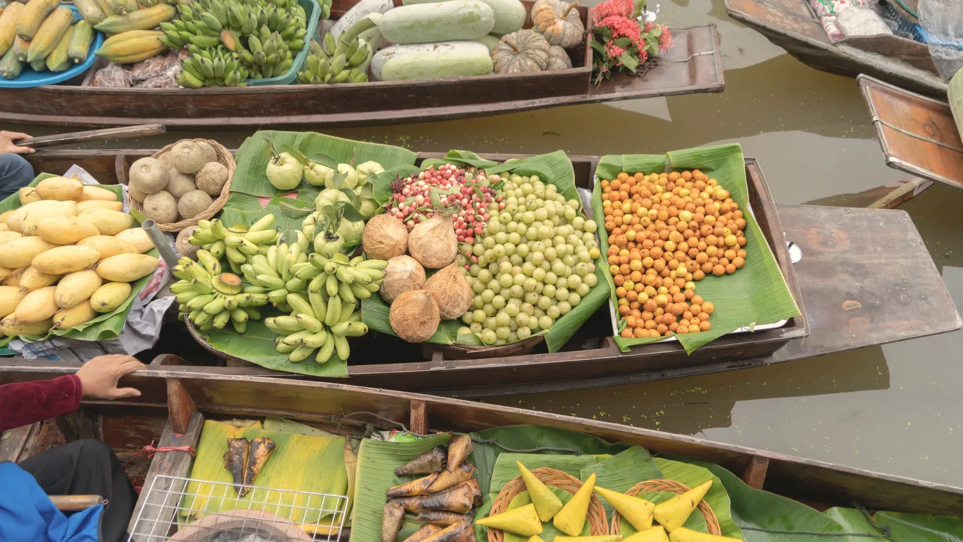
An afternoon floating market on Amphawa Canal near Wat Amphawan Chetiyaram, with parking. TAT says it runs Friday to Sunday, 10.00 am to 8.30 pm, with boat vendors selling seafood, noodles, coffee and sweets. Evening boat trips go to see fireflies in the cork trees.
Railway market
TAT says the local market is called Hoop Rom, meaning umbrella-closing. TAT gives the last station on the line as Mae Klong, and says to reach it from Bangkok by road or by the Mahachai ferry route.
Memorial park
In Amphawa district, built as a memorial at the place NSO says King Rama II was born. NSO lists buildings and galleries of art and culture, an open-air stage for classical drama and khon, and gardens planted with trees named in Thai literature.
Temple
In Amphawa sub-district. NSO describes a royal monument to King Rama II, a prang holding his ashes, and ordination hall murals about his life and his plays. The doors and windows are recorded as showing Thai topiary art, painted in the early Rattanakosin style.
Royal temple
In Mae Klong sub-district. NSO says the revered Luang Pho Wat Ban Laem is a 167-centimetre standing Buddha holding an alms bowl, in late Sukhothai style. Local people hold the image in high regard, according to the report.
Temple
On the Mae Klong River in Mae Klong sub-district. NSO says it is old, presumed built at the same time as Wat Phet Samut, with an ordination hall restored in the reign of King Rama II. It keeps the large drum tied to the province's name.
Tidal mudflat
A sandbar at the Mae Klong river mouth where razor clams live. NSO says the sea covers it at high tide and it reappears when the water drops, and that most people visit between February and April. Ask the Bang Chakreng municipality for tide times before you go.
Historic military camp
At Wat Bang Kung in Bang Khonthi district. NSO calls it a naval camp named in the chronicles, with a King Taksin shrine and memorial. It also records a shrine to the Black Lord covered entirely by banyan roots.
The basics are documented. In academic year 2024 NSO counts 92 schools: 75 under the basic education commission, 8 private and 9 under local administration. Basic-education teachers number 1,435 and pupils 24,208. In vocational and higher education there are 257 lecturers and 4,396 students. For health, fiscal 2024 counted 4 hospitals, 49 sub-district health-promoting hospitals, 58 clinics, 82 doctors and 405 beds, which is one bed per 459 people.
The province is small, flat and mostly rural. Only 18.8 percent of people live inside municipal areas. Because tides push seawater up the river and canals, water quality varies by zone, so ask locals about salt water and flooding before you choose a spot. NSO also records 3 post offices in 2022, covering every district.
We found no official source for typical rents, cost of living, internet speeds or the number of foreign residents, so we give none. Bangkok is about 65 kilometres away by road, but we did not source a journey time. Visit in more than one season and talk to people who live here before committing.
BAANLYY does not yet have local listings, partnered landlords or property managers in Samut Songkhram, so this page is a reference guide, not a property search. Thai law limits what foreigners can own, and the rules for condominiums, leaseholds and company structures differ from one another, so read BAANLYY's ownership guides and take advice from a qualified Thai lawyer before you commit money.
Your visa route matters more than the province you choose. BAANLYY's visa guides cover the long-stay options in plain language and cite the official Thai sources for each. Nothing on this page is legal, tax or immigration advice, and BAANLYY is a property portal and is not a party to independent owners', agents' or agencies' leases or sales.
We left these out rather than guess. If you hold a current official source for any of them, tell us at hello@baanlyy.com.
Yes. NSO's 2025 provincial report says it covers only 416.7 square kilometres, about 0.08 percent of the country, which makes it the smallest province by area.
NSO gives about 65 kilometres along Highway 35, the Thon Buri to Pak Tho road. TAT says to follow that road to the 63rd kilometre for the railway market. We found no official journey time.
NSO counts 186,784 registered residents in 2024, with 89,040 men and 97,744 women. Registered numbers can differ from people actually living there, and about 81 percent live outside municipal areas.
TAT lists the Amphawa floating market, which runs Friday to Sunday, and the Maeklong railway market. NSO adds the Rama II memorial park, Wat Amphawan Chetiyaram, Wat Phet Samut Worawihan, Don Hoi Lot and Bang Kung Camp.
It has 4 hospitals, 3 government and 1 private, and 405 beds, per NSO. We have no official ranking of quality or specialist capacity, so check which hospital covers your needs.
NSO describes a hot season from March to mid-June, rain from mid-July to October and a cool season from November to mid-February, with a yearly average near 29.3 degrees Celsius.
Thai law limits foreign ownership, and the rules differ for condominiums, leasehold and company structures. BAANLYY has no local listings here and gives no advice, so speak to a qualified Thai lawyer first.
Facts on this page were checked against the sources above on 2026-10-12. Official figures change; confirm current numbers and rules with the relevant authority before relying on them.
BAANLYY LLC is a Nevada property portal. Homes are listed by independent owners, agents and agencies; BAANLYY is not a party to their leases or sales. Owners who contact BAANLYY directly can have their home listed and managed by the BAANLYY founding team under a written agreement. General information, not legal, tax, immigration or financial advice.