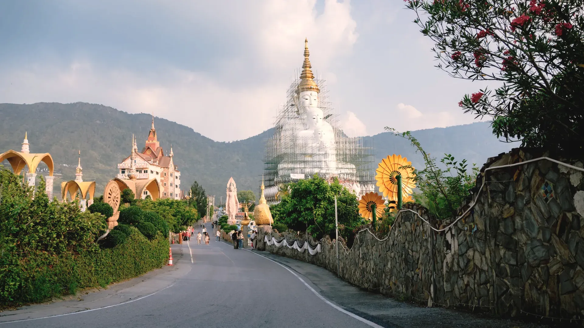
Phetchabun is a large, mountainous lower-northern province with a UNESCO World Heritage site at Si Thep, the cool hills of Khao Kho and Phu Thap Boek, and no railway. Every fact comes from Thai government or UNESCO sources.
NorthRegion
Mueang PhetchabunProvincial capital
เพชรบูรณ์Thai name
Registered population
Phetchabun had 949,408 people in the civil registration system in August 2026 (947,271 Thai nationals and 2,137 registered non-Thai nationals), according to the Department of Provincial Administration. That is the 23rd largest registered population of Thailand's 77 provinces and about 1.4 percent of the national registered total of 65,677,170.
This is the number of people entered in the house registration system for the province, not a count of everyone who lives there. People who work in another province often stay registered at home, and most foreigners on short stays are not in the registry at all. Official table for August 2026 (read by BAANLYY on 14 November 2026) · Compare all 77 provinces
About Phetchabun
Phetchabun covers 12,668.416 square kilometres, according to the National Statistical Office, which makes it one of the larger provinces in the country. It sits where the north, the northeast and the central plains meet, with a long north-south shape: 296 kilometres from top to bottom and only 55 kilometres at its widest. The provincial town is 346 kilometres from Bangkok by Highway 21, and there is no railway line in the province.
At the end of December 2023 the Department of Provincial Administration counted 967,421 registered residents. Only 17.0 percent of them lived inside municipal areas, so this is a province of villages, farms and hill country, not of one big city. Two things bring visitors: the ancient town of Si Thep, which UNESCO inscribed as a World Heritage site in 2023, and the cool highlands around Khao Kho, Nam Nao and Phu Thap Boek, where winter nights can fall below 10 degrees Celsius according to the provincial statistical report.
If you are weighing a move or a long stay, treat this page as a map of what is documented. We could confirm area, registered population, the 2022 economy, the 2023 health and school counts, rainfall for 2023, and the main places to visit. We could not confirm rents, house prices, the size of the foreign community, official 30-year climate normals or any bus timetable, and the list at the end of this page says so. BAANLYY does not have local listings in Phetchabun.
Phetchabun at a glance
Region and neighbours
Lower northern Thailand, on the border between the north, the northeast and the central region. Loei lies to the north, Chaiyaphum and Khon Kaen to the east, Lop Buri to the south, and Phitsanulok, Nakhon Sawan and Phichit to the west. source
Area
12,668.416 square kilometres, or about 7,917,760 rai, up to 55 kilometres wide and 296 kilometres from north to south, at about 114 metres above sea level (National Statistical Office) source
Registered population
967,421 people at 31 December 2023 (475,870 men and 491,551 women), from Department of Provincial Administration data quoted by the National Statistical Office. 17.0 percent lived inside municipal areas. Density 76.36 people per square kilometre. source
Administrative divisions
11 districts, 117 subdistricts and 1,440 villages in 2023. Local government has 1 provincial administrative organisation, 3 town municipalities (Phetchabun, Lom Sak and Wichian Buri), 22 subdistrict municipalities and 102 subdistrict administrative organisations. source
Distance from Bangkok
346 kilometres by Highway 21 (the Saraburi to Lom Sak road) source
Gross provincial product
84,249 million baht in 2022, or 93,465 baht per person (NESDC figures quoted by the National Statistical Office). Agriculture, forestry and fishing made up 26,542 million baht, 31.5 percent of the total. source
Forest cover
2,534,983 rai of forest in 2023, or 32.9 percent of the province (Royal Forest Department data quoted by the National Statistical Office) source
Health facilities, 2023
12 public hospitals, 2 private hospitals, 155 subdistrict health-promoting hospitals and 177 clinics, with 283 doctors and 1,647 hospital beds source
World Heritage
The Ancient Town of Si Thep and its Associated Dvaravati Monuments, inscribed by UNESCO in 2023 (decision 45 COM 8B.41) under criteria (ii) and (iii) source
Where Phetchabun sits
Phetchabun is a basin ringed by mountains. The National Statistical Office describes two ranges, Phetchabun 1 along the west side and Phetchabun 2 along the east, with a flat, bowl-shaped plain between them. About 47 percent of the province is mountain or hill country, and the rest is river plain and farmland.
The Pa Sak River is the main river. It runs north to south through the middle of the plain, crosses seven districts, and eventually joins the Chao Phraya at Ayutthaya. Because the hills shed water in short streams, the Phetchabun Irrigation Project counts 412 water sources in the province: 225 canals, 88 ponds and swamps, 56 concrete weirs, 11 medium reservoirs and 32 small reservoirs.
The report counts 2,534,983 rai of forest, 32.9 percent of the province. That includes 13 national reserved forests, 4 national parks, 4 forest parks, 2 arboretums, 3 wildlife sanctuaries and 5 non-hunting areas. The minerals it lists are limestone, andesite, iron, dolomite, granite, petroleum and gold.
Climate and the seasons
The statistical report describes a tropical climate under the southwest monsoon, the southeast monsoon and the northeast monsoon, with three seasons: rainy from June to October, cool from November to February, and hot from March to May. Highlands such as Nam Nao and Phu Thap Boek are colder than the plain. The report says Nam Nao is coldest in December and January, and that Phu Thap Boek can fall below 10 degrees Celsius in the cool season.
The only measured figures we opened are for 2023, from the Phetchabun weather station. The year had 111 rain days and 1,100.8 millimetres of rain. The heaviest single day was 7 June 2023, with 95.0 millimetres. Average relative humidity was 72.8 percent. The report also gives a highest temperature of 38.9 degrees Celsius and a lowest of 20.4 degrees, but it does not say whether those are daily extremes or monthly averages, so we have not built a claim on them.
That is one year, not a climate normal, and we did not find the Thai Meteorological Department's 30-year averages for Phetchabun. If you plan to live here, the practical point is altitude. The town sits at about 114 metres, so expect heat in March to May, while a house up at Khao Kho or Nam Nao will feel several degrees cooler. Spend a few weeks there in each season before you commit.
History and culture
The statistical report says plainly that no clear record shows who built Phetchabun town or when. It cites Prince Damrong Rajanubhab's analysis that the town was built in two periods on the same site, as shown by Wat Maha That and other old temples. The first was when Sukhothai or Phitsanulok was the northern capital, with a wall 800 metres on each side and a river through the middle. The second was under King Narai of Ayutthaya, with a smaller, lower wall. Treat both as the report's account of a tradition, not a dated fact.
Si Thep is much older. The report says its remains are more than 1,000 years old and compares them to Phimai, Lop Buri and Chanthaburi, and it attributes the work to Khmer builders. UNESCO describes it differently. In its 2023 inscription, UNESCO places Si Thep in the Dvaravati culture of the 6th to the 10th centuries and notes a distinctive local art style, the Si Thep School of Art. UNESCO lists three component parts: the twin-town layout of the inner and outer town, the Khao Klang Nok monument, which it calls the largest surviving Dvaravati monument, and the Khao Thamorrat cave monastery.
The twentieth century left its own marks. The report says the city-pillar shrine at Lom Sak recalls a time during the Second World War when Phetchabun was designated as a possible national capital, and that Wat Tham Sombat was once used to store state treasure while Field Marshal Phibun Songkhram was prime minister. At Khao Kho, a memorial honours the civilians, police and soldiers who died fighting communist insurgents between 1968 and 1982 in the area where Phitsanulok, Phetchabun and Loei meet.
How people earn a living here
Farming is the biggest earner. In 2022 the province's gross product was 84,249 million baht, and agriculture, forestry and fishing contributed 26,542 million baht, or 31.5 percent. Manufacturing came second at 12,555 million baht (14.9 percent), and wholesale and retail trade, including vehicle repair, came third at 9,756 million baht (11.6 percent). Per person that works out at 93,465 baht a year.
The report singles out Phu Thap Boek as the largest cabbage-growing area in Thailand, with terraced fields on the hillsides. The provincial slogan, quoted in the report, calls Phetchabun the town of sweet tamarind. We did not open an official production figure for tamarind or any other crop, so we make no claim about quantities.
Utilities show the scale. In 2022 there were 313,473 electricity customers using 1,052.30 million kilowatt-hours, and the Phetchabun waterworks produced 19,428,084 cubic metres of water for 54,470 users. There were 18 post offices. The report names petroleum and gold among the province's minerals, but it gives no output figures for either.
Getting to Phetchabun
There is no railway in Phetchabun, the statistical report says so directly. Everything is by road. Highway 21, the Saraburi to Lom Sak road, is the main route from Bangkok and runs 346 kilometres to the provincial town. Highway 12, part of the East-West Economic Corridor, crosses the province towards Chaiyaphum and Khon Kaen, and the report says it links to the Phitsanulok hub.
The report also describes an airport about 30 kilometres north of Phetchabun town. It says that no operator has yet applied to open it for scheduled commercial flights, so no commercial flights serve the province. We did not find an official source for the nearest airport that does have scheduled service, and we did not find bus timetables, so both are listed below as unconfirmed.
Distances inside the province matter because it is long. The report puts Si Thep about 130 kilometres from Phetchabun town, Wichian Buri about 110 kilometres, Phu Thap Boek about 73 kilometres, and Nam Nao National Park about 89 kilometres. Khao Kho is closer, at about 32 kilometres to the national park office. Allow time, and plan to drive.
Places worth knowing in Phetchabun
Si Thep Historical Park (อุทยานประวัติศาสตร์ศรีเทพ)
UNESCO World Heritage site
About 130 kilometres from Phetchabun town in Si Thep district, on more than 2,000 rai according to the provincial statistical report. UNESCO inscribed it in 2023 as a serial property of the inner and outer town, Khao Klang Nok and the Khao Thamorrat cave, and dates the Dvaravati culture to the 6th to 10th centuries. The report says an electric tram takes visitors between monuments.
Declared on 18 May 2012 as Thailand's 125th national park, covering 301,698 rai across Lom Sak, Lom Kao, Khao Kho and Mueang Phetchabun districts, about 32 kilometres from the provincial town. The report describes north-south mountain ridges, plant and animal diversity and viewpoints. Nearby are the wind-turbine plateau at about 1,050 metres and the Khao Kho memorial.
Thailand's fifth national park, declared on 4 May 1972 and covering about 966 square kilometres in Lom Kao, Lom Sak and Nam Nao districts, roughly 89 kilometres from Phetchabun town. The highest peak is Phu Dan I Pong at about 1,271 metres, and the park is coldest in December and January. The report lists pine forests, waterfalls and a canyon-like cliff at Khok Mon.
The highest peak in Phetchabun at about 1,768 metres above sea level and roughly 73 kilometres from the provincial town. The report says mist and cool air last all year, winter temperatures can drop below 10 degrees Celsius, and terraced hillside fields make it the largest cabbage-growing area in Thailand. Wat Pa Phu Thap Boek is on the hill.
Declared on 30 October 1998 as the 87th national park, covering about 290 square kilometres across three subdistricts, with its office roughly 37 kilometres from Phetchabun town. The report names Tat Mok waterfall and the 12-tier Song Nang waterfall, whose tiers range from 5 to 100 metres high and can be walked in one day. The forest joins Nam Nao National Park.
On Nikorn Bamrung Road in the municipality, with a Sukhothai-style lotus-bud stupa. The report calls it an old temple tied to the founding of the town and gives its age as about 633 years, which is a traditional figure rather than a dated record. Prince Damrong's analysis of the town's two building periods cites this temple as evidence for the earlier one.
Thung Salaeng Luang National Park (อุทยานแห่งชาติทุ่งแสลงหลวง)
National park (shared with Phitsanulok)
Declared on 29 January 1963 as Thailand's third national park, covering about 1,262.4 square kilometres across districts of Phitsanulok and, in Phetchabun, Khao Kho and Wang Pong. The report praises its scenery and natural character. Because most of it lies on the Phitsanulok side, check which entrance you need before driving.
The documented basics are reasonable for a province of nearly a million people. In 2023 the report counts 12 public hospitals, 2 private hospitals, 155 subdistrict health-promoting hospitals, 8 public health service centres and 177 clinics. It lists 283 doctors, 77 dentists, 131 pharmacists, 1,440 nurses and 1,647 hospital beds. Dividing the registered population by the doctor count gives roughly one doctor for every 3,400 people, which is our own arithmetic and is thinner than a big city. Ask which hospital handles your specialty before you rely on the totals.
For schooling, the 2023 school year had 541 schools, 6,446 classrooms, 7,566 teachers and 122,510 pupils from kindergarten to upper secondary. There were 15 vocational and higher-education institutions with 770 lecturers and 12,283 students. We found nothing official on international schools.
What we could not find is just as important. There is no official figure here for cost of living, typical rents, internet speed or the number of foreign residents. Distances are large and there is no train, so a car matters. Expect Thai-language services outside the town, and visit in both the hot season and the rains before deciding.
Renting, buying and visas
BAANLYY does not run a rental hub or local listings for Phetchabun, so this page is a reference guide and not a property search. Thai law limits what foreigners can own, and the rules for condominiums, leaseholds and company structures differ from one another, so read BAANLYY's ownership guides and take advice from a qualified Thai lawyer before you commit money.
Your visa route matters more than the province you choose. BAANLYY's visa guides cover the long-stay options in plain language and point to the official Thai sources for each. Nothing on this page is legal, tax or immigration advice, and BAANLYY is a property portal and is not a party to independent owners', agents' or agencies' leases or sales.
What we could not confirm
We left these out rather than guess. If you hold a current official source for any of them, tell us at hello@baanlyy.com.
A registered-population figure later than 31 December 2023. The statistical report we opened uses 2023 data and we did not open the DOPA registry.
Cost of living, typical rents and house prices. We found no official source.
The size and make-up of the foreign community in Phetchabun.
Temperature records and official 30-year climate normals from the Thai Meteorological Department. The report gives 2023 rainfall and a highest and lowest temperature without saying whether they are extremes or averages.
The nearest airport with scheduled flights, and any bus or minibus timetable. The report says the airport north of the town has no commercial flights.
A second official area figure. The provincial government site and the Ministry of Commerce page did not load, so the area comes from the National Statistical Office alone.
How much of Wat Maha That and the Si Thep monuments is original and how much has been restored. The sources we opened do not say.
Production figures for tamarind, cabbage and other crops. The report names them without numbers.
Map coordinates for the provincial capital and the places listed. We did not find a government source that names each place and district, so no map is drawn on this page.
FAQ
Questions about Phetchabun
Is Si Thep a UNESCO World Heritage site?
Yes. UNESCO inscribed The Ancient Town of Si Thep and its Associated Dvaravati Monuments on the World Heritage List in 2023, under criteria (ii) and (iii). It has three component parts, including the twin-town layout and the Khao Klang Nok monument.
Can you get to Phetchabun by train or plane?
No train, because the statistical report says the province has no railway. It also says no commercial flights serve the province, so most people drive along Highway 21, which is 346 kilometres from Bangkok.
How cold does it get in Phetchabun?
The town is hot from March to May, but the highlands are cooler. The statistical report says Phu Thap Boek can fall below 10 degrees Celsius in winter and that Nam Nao National Park is coldest in December and January.
How many people live in Phetchabun?
The Department of Provincial Administration counted 967,421 registered residents on 31 December 2023, as quoted by the National Statistical Office. Only 17.0 percent lived inside municipal areas. The registered population section on this page gives the official registry figure for a later month.
What does the Phetchabun economy depend on?
Mostly farming. Agriculture, forestry and fishing produced 26,542 million baht of the province's 84,249 million baht gross product in 2022, or 31.5 percent, ahead of manufacturing at 14.9 percent and trade at 11.6 percent.
Does BAANLYY have rentals or property listings in Phetchabun?
No. BAANLYY does not yet have local listings, partnered landlords or property managers in Phetchabun. This page is a reference guide built from Thai government sources and should not be read as evidence of a rental market.
Where does the information on this page come from?
The National Statistical Office's Phetchabun provincial statistical report for 2024 (mostly 2022 and 2023 data) and UNESCO's World Heritage pages for Si Thep. Anything we could not confirm from those is listed at the end of the page as not confirmed.
Facts on this page were checked against the sources above on 2026-10-12. Official figures change; confirm current numbers and rules with the relevant authority before relying on them.
BAANLYY LLC is a Nevada property portal. Homes are listed by independent owners, agents and agencies; BAANLYY is not a party to their leases or sales. Owners who contact BAANLYY directly can have their home listed and managed by the BAANLYY founding team under a written agreement. General information, not legal, tax, immigration or financial advice.